Tompkins Bend Campground
Lake Ouachita · Arkansas · 75 sites
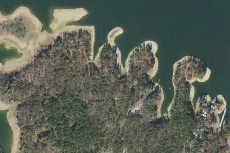
Imagery: USGS The National Map
Overview
Tompkins Bend Campground is a US Army Corps of Engineers campground in Lake Ouachita, Arkansas, with 75 sites in 4 loops. Very shady: nearly every site is under trees. Verizon and AT&T report coverage at every site; T-Mobile reports none.
74 of 75 sites shaded
0 of 75 sites in full sun
1 of 75 sites with clear sky
Map of the campground
Every site from the Recreation.gov listing. Choose a layer to see it across the campground; tap a site to open it in Roam.
Layers
More in Roam Premium
is in Roam Premium, with a 7-day free trial. Try it in Roam
Questions
Which sites at Tompkins Bend Campground are the shadiest?
Nearly all of them. 74 of 75 sites at Tompkins Bend Campground have good shade from the trees, including from the hot afternoon sun.
See the tree canopy in RoamWhich sites at Tompkins Bend Campground get the most sun?
None are truly sunny; the sunniest still have trees over most of the site.
See the tree canopy in RoamWill Starlink work at Tompkins Bend Campground?
Only at a few. About 1 of 75 sites have a clear gap in the trees for Starlink and 3 a partial one; most sit under tall trees. Satellite texting on a phone needs less open sky, but still works best from the most open spot you can find. This is our estimate from tree heights — check with the Starlink app's obstruction check when you arrive.
See the tree canopy in RoamWhich sites at Tompkins Bend Campground are the most level?
7 of 75 sites are flat, and 21 more have a gentle slope most RVs can level with blocks; 47 are steeper, better for tents. Sites that take RVs or trailers fit rigs up to 70 ft.
See the slope at each site in RoamDoes Tompkins Bend Campground have cell service?
Mostly. Verizon and AT&T report coverage at every site; T-Mobile reports none. That's the coverage each carrier reports to the FCC, not a measured signal, so under trees or below a ridge it can be weaker.
See the coverage map in RoamWhen is the best time to see fall color at Tompkins Bend Campground?
October. In a typical year the leaves around Tompkins Bend Campground are at their best in mid to late October, though any one fall can run a week or two early or late. Much of the forest here stays green, so expect color in patches. Roam’s fall foliage map shows how far the color has come this week, free every September through November.
See this week’s fall color in RoamWhat’s the weather like at Tompkins Bend Campground in October?
In October, expect highs around 75°F and lows around 49°F, with about 4.6 inches of rain over the month. Every month’s averages are in Roam Premium.
Open Tompkins Bend in RoamCampground facts
- Sites
- 75 in 4 loops
- Kinds
- 61 for RVs or trailers · 14 tent-only
- Hookups
- 61 with electric
- Longest rig
- 70 ft
- Elevation
- 584–595 ft
- Every site
- Picnic table · Pets allowed · Campfires allowed · Check-in 6 PM, check-out 4 PM
- Managed by
- US Army Corps of Engineers
- Booking
- Reserve on Recreation.gov
How we know Sources and limits
Shade, sun and Starlink are our estimates from Meta and the World Resources Institute’s canopy-height model (about 2 m pixels, from satellite imagery calibrated with space lidar; CC BY 4.0). From 2 m above each site we trace 72 lines out to 60 m and note the tallest tree in each direction. Shade counts trees overhead, the canopy within 30 m and how much of the afternoon sky is blocked. Sun counts how open the southern sky is. Starlink needs open sky above 35°, with the northern half counted twice because US dishes tilt north, and we keep the best spot within 8 m of the site’s post. The model sees tree heights only, not trunks, buildings or hills, so check with the Starlink app when you arrive.
Slope is the ground at each site’s post over about 4 m, from USGS 3DEP 1 m lidar: level under 2%, gentle to 4% (most rigs level on blocks), sloped to 8% (fine for a tent), steep beyond.
Cell coverage is from the FCC Broadband Data Collection (carrier filings as downloaded May 2026): each site is tested against each carrier’s modelled outdoor 4G/5G coverage. It is what the carriers report, not a measured signal.
Fall color is the typical peak from NASA’s MODIS satellite record of when leaves change (2001–2023), limited to deciduous and mixed forest with USGS land cover (NLCD), calibrated to the USA National Phenology Network’s ground reports of colored leaves (CC BY 4.0). It is an average of many autumns, so the page gives a window, not a date.
Weather is NOAA’s 1991–2020 climate normals for the campground. Sites and facts are from Recreation.gov’s open data (July 2026). Map imagery: USGS The National Map.
From the campground’s Recreation.gov listing: “The campground consists of 77 sites including 63 sites with electric hookups and 69 sites with water hookups. Most sites will accommodate two camping units. Other amenities include a dump station, fish cleaning station, hot showers, playground and a boat ramp. Lake Ouachita is fed from the cool waters of the Ouachita River in central Arkansas. Surrounded by the Ouachita Mountains and National Forest, it's crystal waters span over 40,000 acres and extend for 30 miles, making it the largest lake completely in the state of Arkansas.”
Page data as of October 15, 2026. Full source notes are in each layer’s info in the app.