Potters Creek Park
Canyon Lake · Texas · 121 sites
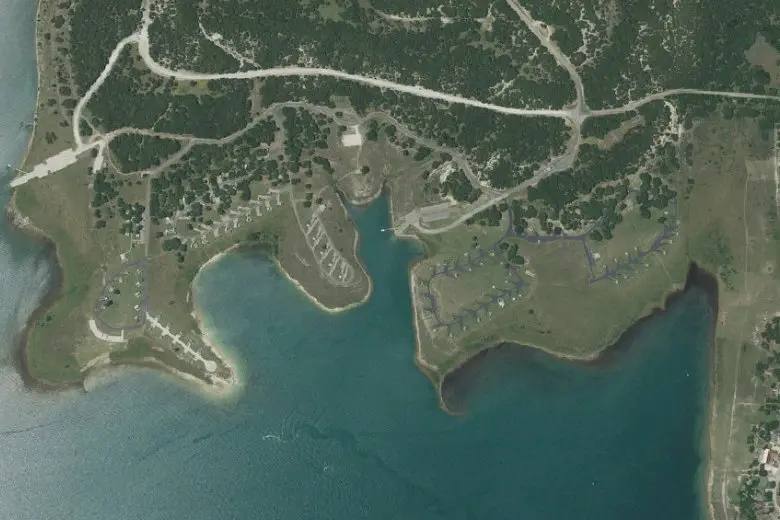
Imagery: USGS The National Map
Overview
Potters Creek Park is a US Army Corps of Engineers campground in Canyon Lake, Texas, with 121 sites in 8 loops. Mostly open: only a few shady sites. T-Mobile, Verizon and AT&T report coverage at every site.
22 of 121 sites shaded
96 of 121 sites in full sun
105 of 121 sites with clear sky
Map of the campground
Every site from the Recreation.gov listing. Choose a layer to see it across the campground; tap a site to open it in Roam.
Layers
More in Roam Premium
is in Roam Premium, with a 7-day free trial. Try it in Roam
Questions
Which sites at Potters Creek Park are the shadiest?
Only a few. 22 of 121 sites have good shade; most sit in the open.
See the tree canopy in RoamWhich sites at Potters Creek Park get the most sun?
Plenty. 96 of 121 sites are open to the south and the sky — easy for solar panels, and warm on cool mornings.
See the tree canopy in RoamWill Starlink work at Potters Creek Park?
Easy here. About 105 of 121 sites have open sky for a Starlink dish, and 7 more have a partial gap. Satellite texting on a phone needs less open sky, but still works best from the most open spot you can find. This is our estimate from tree heights — check with the Starlink app's obstruction check when you arrive.
See the tree canopy in RoamWhich sites at Potters Creek Park are the most level?
34 of 121 sites are flat, and 38 more have a gentle slope most RVs can level with blocks; 49 are steeper, better for tents. Sites that take RVs or trailers fit rigs up to 60 ft.
See the slope at each site in RoamDoes Potters Creek Park have cell service?
Yes. T-Mobile, Verizon and AT&T all report coverage at every site at Potters Creek Park. That's the coverage each carrier reports to the FCC, not a measured signal, so under trees or below a ridge it can be weaker.
See the coverage map in RoamWhat’s the weather like at Potters Creek Park in October?
In October, expect highs around 81°F and lows around 57°F, with about 4.2 inches of rain over the month. Every month’s averages are in Roam Premium.
Open Potters Creek Park in RoamCampground facts
- Sites
- 121 in 8 loops
- Kinds
- 98 for RVs or trailers · 17 tent-only · 6 group sites
- Hookups
- 121 with electric
- Longest rig
- 60 ft
- Accessible
- 47 sites
- Elevation
- 913–937 ft
- Amenities
- Accessible showers, Boat ramp, Camp host, Drinking water, Dump station, Flush toilets, Lake access, Paved roads, Showers, Water spigots
- Every site
- Pets allowed · Check-in 3 PM, check-out 2 PM
- Managed by
- US Army Corps of Engineers
- Booking
- Reserve on Recreation.gov
How we know Sources and limits
Shade, sun and Starlink are our estimates from Meta and the World Resources Institute’s canopy-height model (about 2 m pixels, from satellite imagery calibrated with space lidar; CC BY 4.0). From 2 m above each site we trace 72 lines out to 60 m and note the tallest tree in each direction. Shade counts trees overhead, the canopy within 30 m and how much of the afternoon sky is blocked. Sun counts how open the southern sky is. Starlink needs open sky above 35°, with the northern half counted twice because US dishes tilt north, and we keep the best spot within 8 m of the site’s post. The model sees tree heights only, not trunks, buildings or hills, so check with the Starlink app when you arrive.
Slope is the ground at each site’s post over about 4 m, from USGS 3DEP 1 m lidar: level under 2%, gentle to 4% (most rigs level on blocks), sloped to 8% (fine for a tent), steep beyond.
Cell coverage is from the FCC Broadband Data Collection (carrier filings as downloaded May 2026): each site is tested against each carrier’s modelled outdoor 4G/5G coverage. It is what the carriers report, not a measured signal.
Weather is NOAA’s 1991–2020 climate normals for the campground. Sites and facts are from Recreation.gov’s open data (July 2026). Map imagery: USGS The National Map.
From the campground’s Recreation.gov listing: “The park is open year-round and offers RV and tent sites as well as overnight screened shelters, and a group site, all with electric and water hookups. Every site has a picnic table, fire ring, and grill, water and electricity. Park Amenities include flush toilets, showers, drinking water, and two dump stations. The park also has two boat ramps with docks, a fishing pier and beach. Rangers patrol the park and hosts are on-site year-round. The park is settled among Juniper and native Oaks on gently sloping terrain on the shore of Canyon Lake. Thick oak and juniper surround the upper campsites; sites closer to the waterfront are in full sun. Grassy fields of native hill country plants and wildflowers dot the landscape. Rocky outcroppings are scattered throughout the park.”
Page data as of October 15, 2026. Full source notes are in each layer’s info in the app.